Software solution
Cropsense
AI-based yield forecasting, recognition and monitoring of agricultural land
Target groups
- Conventional farming
- Organic farming
- Authorities
- Business and industry
AI-based yield forecasting, recognition and monitoring of agricultural land
Cropsense uses historical Sentinel-2 satellite data to train an AI model that is used to monitor agricultural land. With the help of Cropsense, it is possible to determine on a daily basis which agricultural crops are grown on which pieces of land. This makes it possible to better estimate expected yields and the effects of weather, climate or pest events.
Cropsense generates area-specific yield forecasts for selected agricultural crops. The crop growth curve is simulated, taking into account soil, weather and historical growth patterns. By using crop growth models, weather data and current satellite data, the yield forecast takes into account current events such as drought periods and adjusts the yield forecast accordingly.
LOOK INSIDE
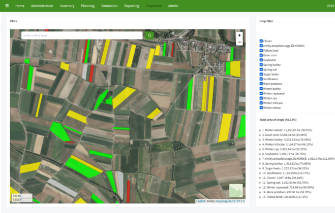
AI-based recognition and monitoring of agricultural land
Cropsense identifies which agricultural crops are grown on which area based on daily updated satellite data.
In Cropsense area monitoring, the areas classified by the AI model on the basis of the agricultural crops grown are displayed and compared with stored land use data.
Areas with a very likely match of detected and stored crop are marked green, areas with a very lower match probability are marked yellow and red.
LOOK INSIDE
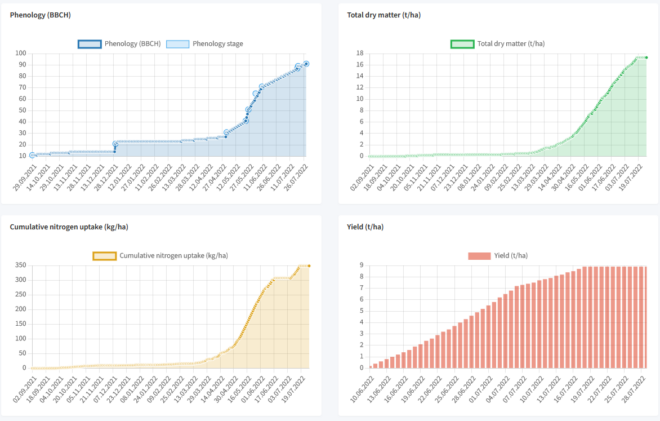
Model-based yield forecasting
The Cropsense yield forecast can be run for selected agricultural crops and any area.
Plant growth, dry matter, nitrogen consumption and yield in tons per hectare are simulated. The simulation takes into account weather forecast data and historical data concerning growth path (based on historical satellite images), weather and soil.